Overview of Mt Kenya
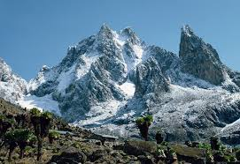
Rising majestically from the heart of Kenya, Mount Kenya is one of Africa’s premier high-altitude trekking and climbing destinations. Standing at 5,199 metres (17,057 ft), it is the second-highest mountain in Africa and attracts climbers and trekkers from around the world seeking to summit its dramatic volcanic peaks.
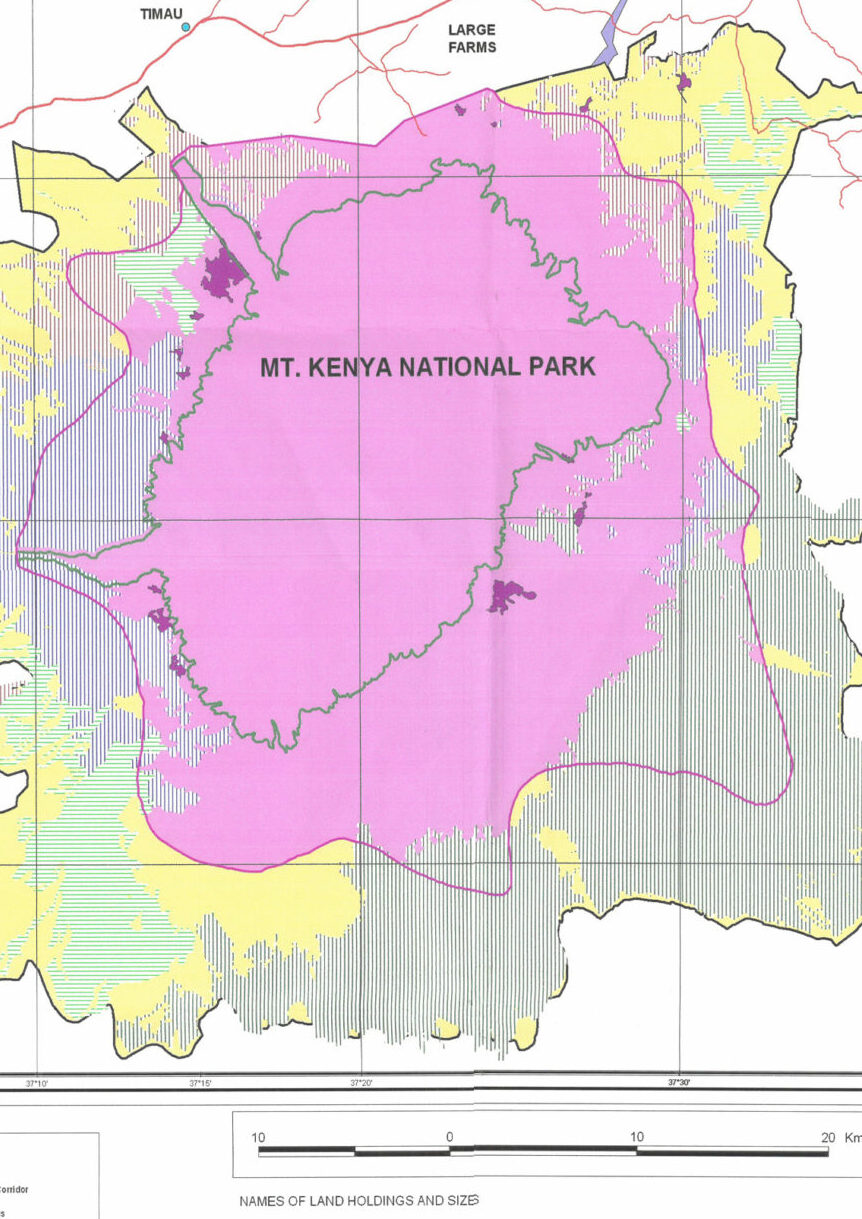
The mountain lies within Mount Kenya National Park, a protected alpine wilderness that surrounds the massif. The highest summit, Batian, rises to 5,199 metres, with its twin peak Nelion just below it. For most visitors climbing Mount Kenya, the goal is Point Lenana (4,985 m)—a non-technical trekking summit that offers one of the most spectacular sunrise viewpoints in Africa.
Most visitors aim for Point Lenana (4,985 m), a non-technical trekking peak accessible via several scenic routes that traverse forests, bamboo zones, alpine moorlands, and glacial valleys. The climb offers an extraordinary combination of high-altitude adventure, rare afro-alpine ecosystems, and dramatic volcanic scenery.
Unlike many high mountains, Mount Kenya allows trekkers to experience true alpine landscapes in just a few days, making it ideal for climbers seeking a challenging but achievable summit in East Africa.
It is a UNESCO World Heritage Site (1997) and Biosphere Reserve (1978), recognized globally for its ecological, hydrological, and cultural significance.
Location & Access:
Located about 180 km north of Nairobi, the park spans the counties of Nyeri, Kirinyaga, Embu, and Meru, covering approximately 715 square kilometers of alpine peaks, glaciers, and montane forests.
Surrounding it is the Mount Kenya Forest Reserve, forming a larger conservation complex of more than 2,100 square kilometers.
Where Is Mount Kenya Located?
Mount Kenya is located in central Kenya, about 150 km (93 miles) northeast of Nairobi, the country’s capital. The mountain sits almost directly on the Equator, rising dramatically from Kenya’s central highlands and forming the centerpiece of Mount Kenya National Park.
Geographically, Mount Kenya lies between Nyeri, Meru, Embu, Kirinyaga, and Laikipia counties, making it accessible from several different sides of the mountain. This central position allows climbers to approach the peak through multiple established trekking routes and park gates.
Most climbers begin their Mount Kenya expeditions from nearby gateway towns that provide access to the main climbing routes:
- Nanyuki – the most popular base for climbers approaching via the Sirimon Route
- Naro Moru – the traditional starting point for the Naro Moru Route
- Chogoria – the gateway to the scenic Chogoria Route
These towns serve as the primary staging points for climbing Mount Kenya, where trekkers arrange guides, porters, park permits, and transport to the park gates before beginning their ascent. Because the mountain is only 3–4 hours by road from Nairobi, Mount Kenya is also one of the most accessible high-altitude climbs in Africa, making it a popular choice for trekkers visiting Kenya.
Mount Kenya National Park vs Mount Kenya Forest Reserve
The protected landscape surrounding Mount Kenya is divided into two adjoining conservation areas: Mount Kenya National Park and the Mount Kenya Forest Reserve. Together they cover about 1,420 km² and form a single ecological system protecting the mountain from its lower montane forests to the alpine summit zone. The national park protects the high-altitude climbing and trekking areas, while the forest reserve safeguards the lower forest slopes and water catchments, functioning as a buffer around the park.
| Feature | Mount Kenya National Park | Mount Kenya Forest Reserve |
|---|---|---|
| Size | ~715 km² | ~705 km² |
| Elevation Range | Above ~3,200 m | ~2,000–3,200 m |
| Landscape | Alpine moorlands, glaciers, summit peaks | Dense montane forest |
| Management | Kenya Wildlife Service (KWS) | Kenya Forest Service (KFS) |
| Main Role | Mount Kenya trekking and climbing zone | Forest protection and watershed buffer |
| Activities | Climbing, trekking, alpine camping | Forest conservation, watershed protection |
Read more on Access and Travel Logistics for Mount Kenya
Why Climb Mount Kenya?
Mount Kenya offers one of the most diverse mountain environments in Africa.
Highlights of climbing Mount Kenya include:
- Reaching Point Lenana, one of Africa’s most accessible high-altitude summits
- Trekking through UNESCO-protected afro-alpine ecosystems
- Seeing rare plants such as giant lobelias and giant groundsels
- Spectacular views across central Kenya toward Mount Kilimanjaro on clear mornings
- Unique wildlife encounters within Kenya Wildlife Service protected areas
The mountain is also culturally significant to the Kikuyu, Meru, and Embu communities, who traditionally regard the summit as sacred.
Guided Mount Kenya Treks to Point Lenana
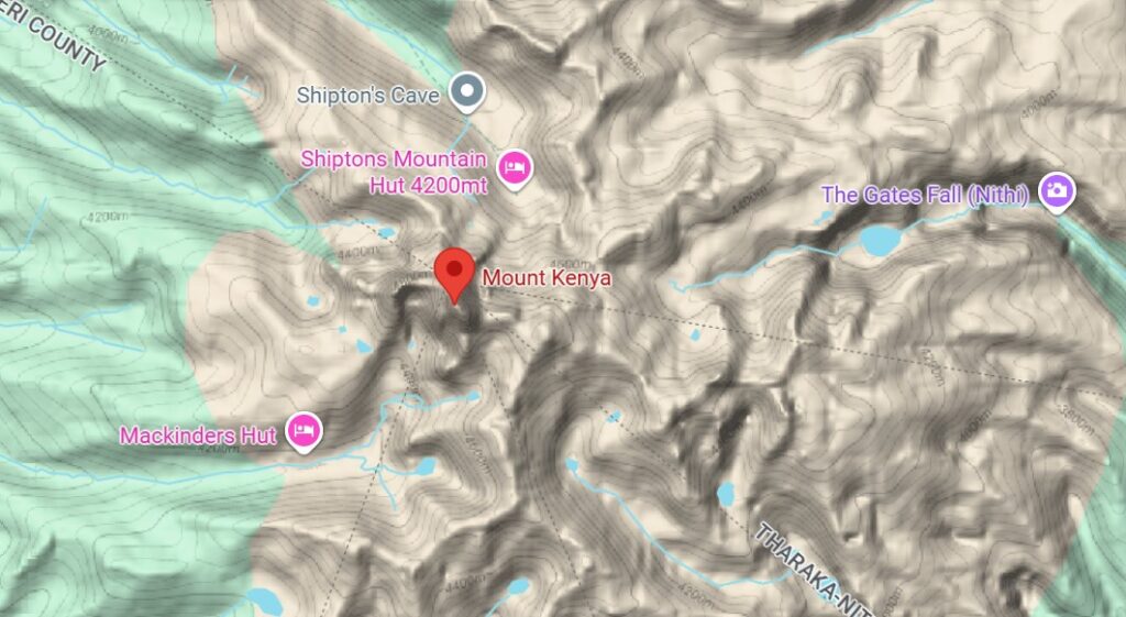
Climbing Mount Kenya is one of the most rewarding high-altitude trekking experiences in East Africa. Most visitors climb to Point Lenana, the main trekking summit at about 4,984 m, while the higher peaks, Batian and Nelion, require technical rock-climbing experience.
A Mount Kenya climb takes you through forest, bamboo, moorland, alpine valleys, tarns, rocky ridges, and cold summit terrain. It is more than a hike: it is a multi-day mountain journey that requires proper planning, guides, gear, acclimatization, and realistic pacing.

🏔️ Geography and Geology
Mount Kenya is an ancient stratovolcano, estimated to have formed about 3 million years ago during the Pleistocene epoch.
Its once massive crater has eroded into a ring of peaks — the highest being Batian (5,199 m), Nelion (5,188 m), and Point Lenana (4,985 m).
Key Geographic Facts
- Coordinates: 0°09′S, 37°18′E (almost on the Equator)
- Elevation Range: 1,200 m – 5,199 m
- Main Valleys: Teleki, Hobley, Gorges, and Mackinder
- Major Rivers: Tana, Thuchi, Sagana, Nithi, and Ewaso Ng’iro
- Rock Composition: Basalt, trachyte, and phonolite, shaped by glaciers and erosion
Mount Kenya’s upper slopes still host remnant glaciers — including the Lewis, Tyndall, Darwin, and Gregory glaciers — though these are shrinking rapidly under global warming.
Read more on Mount Kenya’s Geography and Geology.
🌿 Ecosystems and Biodiversity
Mount Kenya National Park encompasses an extraordinary range of ecological zones, rising from tropical rainforest to alpine desert in less than 50 kilometers.
Vegetation Zones by Altitude
| Zone | Altitude (m) | Dominant Vegetation |
|---|---|---|
| Montane Forest | 1,800–2,500 | Podocarpus, Croton, Juniperus, and olive trees |
| Bamboo Zone | 2,500–3,000 | Yushania alpina bamboo belts |
| Heath & Moorland | 3,000–3,800 | Heather, tussock grasses, Protea |
| Afro-Alpine | 3,800–4,500 | Giant lobelias (Lobelia telekii), tree senecios (Dendrosenecio keniodendron) |
| Nival (Glacial) Zone | Above 4,500 | Bare rock, lichens, and seasonal snow |
Key Wildlife
Mount Kenya’s forests and moorlands harbor over 80 mammal species and 160 bird species, including many endemics and threatened species.
Mammals:
- African Elephant (Loxodonta africana)
- Mountain Bongo (Tragelaphus eurycerus isaaci, critically endangered)
- Giant Forest Hog, Buffalo, Bushbuck, Tree Hyrax, Colobus Monkey, Serval, and Leopard (including rare melanistic “black leopards”).
Birds:
- Jackson’s Francolin (endemic)
- Scarlet-tufted Malachite Sunbird, Lammergeier, Tacazze Sunbird, Hartlaub’s Turaco, Bearded Vulture, and Augur Buzzard.
Reptiles and Amphibians:
- Jackson’s Chameleon, Kenya Horned Viper, Mount Kenya Reed Frog — all adapted to the cold, misty climate.
Mount Kenya’s biodiversity is vital to East Africa’s ecological integrity — serving as a refuge for species displaced by human activity in surrounding lowlands.
Read more on Biodiversity & Wildlife of Mount Kenya National Park
The Peaks of Mount Kenya
Mount Kenya has three main summits, each offering a different type of climbing experience.
| Peak | Elevation | Difficulty | Typical Visitors |
|---|---|---|---|
| Batian | 5,199 m | Technical rock climb | Experienced alpine climbers |
| Nelion | 5,188 m | Technical rock climb | Advanced climbers |
| Point Lenana | 4,985 m | Trekking peak | Most visitors |
Point Lenana is the most commonly climbed summit, requiring no ropes or technical climbing skills. However, the altitude and terrain still demand good physical fitness and proper acclimatization.
Climate and Glacial Change
Mount Kenya’s equatorial location gives it a unique “alpine tropical” climate: warm, humid foothills giving way to freezing summit zones.
Climate Overview
- Long Rains: March–June
- Short Rains: October–December
- Dry Seasons: January–March, July–October
- Temperature Range: +25°C at base to –5°C near summits
Glacial Retreat
Over the last century, Mount Kenya has lost over 90% of its ice cover. The Lewis Glacier, once 1.6 km long, is projected to disappear by the mid-2030s.
Glacial melt affects not just biodiversity but also water security for millions of Kenyans who rely on rivers fed by these ice reserves.
KWS, UNEP, and the University of Nairobi maintain climate stations to monitor ice loss, rainfall, and stream flow as part of global glacial research.
Cultural and Mythological Significance
For the Kikuyu, Embu, and Meru peoples, Mount Kenya is the home of Ngai, the creator God.
They call it Kirinyaga — “Mountain of Whiteness” — and traditionally built homes with doors facing the summit to honor Ngai’s presence.
Rituals, prayers, and sacrifices were offered at sacred fig trees (mugumo) or mountain clearings facing the peaks. These traditions preserved forests as sacred landscapes long before modern conservation laws.
The mountain’s role in spirituality continues today, symbolizing unity, strength, and divine connection for all Kenyans — reflected in its place on the national coat of arms and currency.
Management and Conservation
Governance
Mount Kenya National Park is managed by the Kenya Wildlife Service (KWS) in partnership with:
- Kenya Forest Service (KFS)
- Mount Kenya Trust (MKT)
- Rhino Ark Charitable Trust
- County Governments (Nyeri, Embu, Meru, Kirinyaga)
- Local Community Forest Associations (CFAs)
Together, they implement the Mount Kenya Ecosystem Management Plan (2020–2030) — integrating wildlife protection, community livelihoods, and tourism development.
Key Conservation Initiatives
- Mount Kenya Fencing Project: 450 km of solar-powered fence protecting forest boundaries, reducing human–wildlife conflict.
- Reforestation: Over 2 million indigenous trees planted by Mount Kenya Trust since 2000.
- Elephant Corridors: Linking Mount Kenya with the Aberdare Range to maintain wildlife movement.
- Anti-Poaching Patrols: Joint ranger teams combating illegal logging, grazing, and poaching.
- Community Education: Local conservation clubs and school programs promoting environmental awareness.
These collaborative measures have led to significant forest recovery and reduced poaching incidents over the last decade.
Research and Monitoring
Mount Kenya is a hub for long-term ecological and climate research.
Key Research Areas
- Glacial Monitoring: Tracking ice volume loss and hydrological shifts.
- Biodiversity Surveys: Annual counts of elephants, bongos, and birds.
- Forest Carbon Studies: Measuring carbon sequestration and REDD+ potential.
- Hydrology & Climate Modeling: Assessing water flow patterns and catchment resilience.
Research Institutions Involved
- Kenya Wildlife Service Research Unit (Naro Moru)
- Kenya Meteorological Department
- University of Nairobi
- British Antarctic Survey
- Mount Kenya Trust Research Partnership
Mount Kenya’s datasets contribute to global understanding of climate change impacts on equatorial glaciers and mountain ecosystems.
Sustainable Tourism and Responsible Travel
Tourism is vital to Mount Kenya’s conservation — generating revenue that funds rangers, education, and community projects.
KWS promotes a model of low-impact, high-value eco-tourism.
Sustainable Practices
- Eco-certified Lodges: Serena Mountain Lodge, Castle Forest Lodge, and Fairmont Safari Club use solar energy and recycle wastewater.
- Community Tourism: Local cooperatives run homestays and cultural walks in Chogoria, Naro Moru, and Imenti.
- Carbon-Neutral Expeditions: Tree-planting and reforestation programs for visitors to offset emissions.
- Plastic-Free Park: Single-use plastics are banned; biodegradable products are encouraged.
“Leave No Trace” Principles
All climbers and hikers must pack out their waste, stay on marked trails, and avoid disturbing wildlife.
Tourism here is designed to support, not strain, the mountain’s delicate ecosystems.
Community and Human–Wildlife Coexistence
Communities surrounding Mount Kenya depend on its forests for water, firewood, and grazing — but coexistence with wildlife has required innovation.
Conflict Mitigation
- Electric Fencing: Keeps elephants from raiding farms while preserving corridors.
- Beekeeping Projects: “Bee fences” deter elephants naturally and generate income.
- Livelihood Alternatives: Beekeeping, dairy farming, and tree nurseries reduce reliance on forest resources.
- Compensation Programs: KWS and partners reimburse verified wildlife damage cases.
The result has been a 60% reduction in human–wildlife conflicts and greater community participation in conservation.
Routes, costs, difficulty, itineraries, gear, permits and safety
Climbing Mount Kenya usually means trekking to Point Lenana, the mountain’s main non-technical trekking summit at about 4,984 m, rather than technical climbing to Batian or Nelion. Batian, at 5,199 m, and Nelion, at 5,188 m, are Mount Kenya’s highest peaks and require technical rock-climbing ability, while Point Lenana is the peak reached by most guided trekkers. Kenya Wildlife Service identifies Batian, Nelion and Point Lenana as the mountain’s three highest peaks, and describes Mount Kenya National Park as both a World Heritage Site and Biosphere Reserve.
Mount Kenya is not a casual day hike. It is a high-altitude mountain trek through forest, bamboo, heath, moorland, alpine desert and glacial high country. The best climb is the one that matches your fitness, route choice, number of days, acclimatization needs, budget and summit goal.
Climbing Mount Kenya usually means trekking to Point Lenana, the main non-technical summit at about 4,984 m. Batian and Nelion are higher, at 5,199 m and 5,188 m, but they are technical rock-climbing peaks rather than ordinary trekking summits.
Climbing Mount Kenya at a Glance
| Question | Best Answer |
|---|---|
| Main trekking summit | Point Lenana, about 4,984 m |
| Highest technical summit | Batian, 5,199 m |
| Second technical summit | Nelion, 5,188 m |
| Best routes for trekkers | Sirimon, Chogoria, Naro Moru |
| Best route combination | Sirimon up, Chogoria down |
| Best duration for most trekkers | 4 to 5 days |
| Minimum common trek | 3 days, usually faster and harder |
| Best for beginners | 4 or 5 day guided trek to Point Lenana |
| Technical climbing needed? | Only for Batian and Nelion |
| Main risks | Altitude sickness, cold, rain, exhaustion, poor acclimatization |
| Payment mode | KWS lists eCitizen payment via M-Pesa or Visa Card |
| Guide requirement | KWS says visitors should enter with a qualified and certified guide |
Mount Kenya Climbing Routes
Several trekking routes lead to the summit area, each offering different scenery and levels of difficulty.
Sirimon Route
- Considered the most gradual and best for acclimatization
- Scenic alpine landscapes and fewer steep sections
- Common approach for summit attempts
Naro Moru Route
- Fastest and most direct route
- Passes through the famous Vertical Bog
- Popular but more physically demanding
Chogoria Route
- Often considered the most scenic route
- Includes dramatic features such as:
- Lake Michaelson
- Temple Cliffs
- Gorges Valley
Many climbers combine routes—for example ascending via Sirimon and descending via Chogoria—to experience different landscapes.
Typical Mount Kenya Trekking Itinerary
Most visitors reach Point Lenana over 4–5 days, allowing time for proper altitude acclimatization.
| Day | Route Stage | Elevation |
|---|---|---|
| Day 1 | Park gate to first camp | ~3,300 m |
| Day 2 | Trek through alpine moorland | ~4,000 m |
| Day 3 | High camp near summit | ~4,700 m |
| Day 4 | Summit attempt at sunrise | 4,985 m |
| Day 5 | Descent through forest zone | — |
Summit attempts typically begin around 2–3 AM, allowing climbers to reach Point Lenana for sunrise over the African plains.
How Difficult Is Mount Kenya?
Mount Kenya is a moderate to challenging high-altitude trek. Reaching Point Lenana does not require technical climbing, but it does require fitness, warm clothing, good boots, steady pacing, and respect for altitude.
The main challenges are:
- high altitude near 5,000 m
- cold summit conditions
- long trekking days
- steep and rocky sections
- early-morning summit push
- changing mountain weather
Beginners can climb Mount Kenya successfully with a good guide, enough days, and proper preparation.
What to Pack for Mount Kenya
Bring:
- waterproof hiking boots
- warm layers
- fleece or insulated jacket
- waterproof jacket and trousers
- gloves and warm hat
- headlamp
- sleeping bag
- trekking poles
- water bottles or hydration bladder
- sunscreen and sunglasses
- snacks
- first aid basics
- personal medication
- power bank
Mount Kenya can be warm at lower elevations and freezing near summit level, so layering is essential.
Who Should Climb Mount Kenya?
Mount Kenya is ideal for:
- fit first-time trekkers
- experienced hikers
- adventure travelers
- photographers
- groups and private expeditions
- visitors wanting a quieter alternative to Kilimanjaro
- climbers interested in technical peaks such as Batian or Nelion
It may not be ideal for visitors with limited fitness, unmanaged medical conditions, poor cold-weather gear, or only one or two free days.
Why Climb Mount Kenya?
Mount Kenya offers a rare combination of high-altitude trekking, alpine scenery, dramatic peaks, glacial valleys, moorland, lakes, cliffs, and sunrise summit views. It is Kenya’s highest mountain and one of Africa’s most beautiful trekking landscapes.
For most visitors, the goal is Point Lenana: a serious but achievable summit that gives the feeling of a true mountain expedition without requiring technical rock climbing.
Book a Mount Kenya Climb
Choose your Mount Kenya climb based on your fitness, route preference, budget, and number of days available. For most travelers, a 4-day or 5-day guided trek to Point Lenana offers the best balance of safety, scenery, acclimatization, and summit success.
Recommended climb: Sirimon Route up, Chogoria Route down
Best duration: 4–5 days
Best summit for trekkers: Point Lenana
Best for: Active travelers, hikers, groups, photographers, and adventure seekers
Trekking, Climbing, and Eco-Adventure
Mount Kenya is East Africa’s premier climbing destination, offering everything from forest hikes to technical ascents.
Main Routes
- Sirimon: Gradual, scenic, excellent acclimatization.
- Naro Moru: Fastest ascent; steep “Vertical Bog” section.
- Chogoria: Most beautiful, passing Lake Ellis and Gorges Valley.
- Kamweti and Burguret: Remote, for seasoned trekkers.
Point Lenana (4,985 m) is reachable by most fit hikers; Batian and Nelion require technical rock climbing.
Conservation in Adventure
- Licensed guides and porters follow KWS safety and environmental protocols.
- Mountaineering fees contribute to rescue readiness and trail maintenance.
- Climbers are encouraged to minimize noise, avoid open fires, and camp in designated sites only.
Read more on Mount Kenya Climbing Packages or get details on trekking/climbing on this: Mount Kenya Trekking, Climbing & Permit Guide
Best Time to Climb Mount Kenya
Mount Kenya can be climbed year-round, but certain months offer better weather conditions.
| Season | Conditions |
|---|---|
| January – March | Clear skies, best climbing weather |
| June – October | Dry season with stable conditions |
| April – May | Heavy rains, difficult trekking |
| November | Short rains |
The clearest summit views often occur during the dry seasons.
Mount Kenya Climbing Permits & Park Fees
Climbing Mount Kenya requires permits issued by Kenya Wildlife Service, which manages Mount Kenya National Park.
Fees typically include:
- Park entry
- Mountain rescue services
- Camping or hut accommodation
- Conservation fees
Permits are obtained through the park gates or authorized tour operators.
Threats and Conservation Challenges
Despite decades of protection, Mount Kenya faces ongoing environmental pressures:
- Climate Change: Accelerating glacier loss and changing rainfall patterns.
- Deforestation: Illegal logging and encroachment in forest peripheries.
- Wildfires: Increased frequency during dry seasons.
- Pollution: Littering by unregulated visitors and agricultural runoff.
- Population Growth: Expanding farmland near buffer zones.
Mitigation Efforts
- Community forest monitoring and restoration.
- Policy enforcement under the Wildlife Conservation and Management Act (2013).
- Climate adaptation research and reforestation corridors.
- Youth-led conservation education programs.
The long-term sustainability of Mount Kenya depends on collective responsibility — local communities, tourists, scientists, and policymakers working together.
Why Mount Kenya Matters
Mount Kenya is not only a national symbol but also an ecological keystone for East Africa:
- It sustains rivers that power hydroelectric dams (Seven Forks Scheme).
- Its forests store millions of tons of carbon.
- Its wildlife corridors connect three major ecosystems: Aberdare Range, Laikipia Plateau, and Meru lowlands.
- Its cultural and spiritual heritage inspires conservation ethics grounded in reverence.
Protecting Mount Kenya is protecting Kenya’s water, climate stability, and identity.
Do You Need a Guide to Climb Mount Kenya?
While experienced trekkers can technically climb independently, most visitors hire:
- Licensed mountain guides
- Porters for equipment
- Cooks for multi-day expeditions
Guides help with navigation, altitude safety, logistics, and weather assessment, significantly improving summit success rates. Do let us know via bookings@mtkenyapar.org email if you want to book a guide and plan your trekking with us.
Altitude and Safety
Although Point Lenana is a trekking summit, the altitude is significant.
Key safety considerations include:
- Allow time for acclimatization
- Stay hydrated
- Ascend gradually
- Recognize symptoms of acute mountain sickness (AMS)
Common symptoms include headache, nausea, fatigue, and dizziness.
Essential Gear for Climbing Mount Kenya
Climbers should be prepared for rapidly changing mountain weather.
Typical gear includes:
- Insulated jacket and thermal layers
- Waterproof trekking boots
- Gloves and warm hat
- Trekking poles
- Headlamp for summit night
- Sleeping bag rated for freezing temperatures
Temperatures near the summit can drop below freezing before sunrise.
Why Mount Kenya Is One of Africa’s Greatest Treks
Mount Kenya offers something rare in global mountaineering: dramatic alpine landscapes, wildlife encounters, and high-altitude adventure within a relatively short expedition.
For many trekkers, the experience of watching sunrise from Point Lenana, with glaciers and jagged volcanic peaks rising above the clouds, becomes one of the most memorable moments of travel in East Africa.
✅ Planning to climb Mount Kenya?
Explore detailed guides to routes, permits, trekking itineraries, and preparation advice to make your ascent safe, successful, and unforgettable.
In Summary
Mount Kenya National Park stands as a rare meeting point of spirituality, science, and sustainability.
It is both a mountain of the gods and a barometer of the planet’s health — a living laboratory showing how climate change, biodiversity, and human values intersect.
Conservation here is not only about preserving glaciers or forests; it is about protecting the balance of life — for elephants, for farmers, for climbers, and for generations yet to come.
In the words of a Kikuyu proverb:
“Kirinyaga ni itego ria Ngai — Mount Kenya is the altar of God.”
Protecting it is, therefore, not just a national duty — it is a sacred trust.
Climbing Nelion on Mount Kenya: Route, Difficulty and Guided Expeditions
Nelion is Mount Kenya’s second-highest summit, rising to 5,188 metres above sea level. It is…
Sirimon Route Mount Kenya: Itinerary, Difficulty & Camps
The Sirimon Route is Mount Kenya’s principal north-western approach and one of the best routes…
Mount Kenya Batian Tour Package: 7-Day Technical Climb Guide
Technical ascent of Mount Kenya’s highest summit The 7-day Mount Kenya Batian tour package is…
Mount Kenya Lenana Tour Package
Guided 4-day trek to Point Lenana, Mount Kenya’s main trekking summit The 4-day Mount Kenya…
Mount Kenya Burguret Route Guide
Remote wilderness route, forest approach, Highland Castle, route-finding, camping logistics and Point Lenana summit planning…
5-Day Climbing Chogoria Route
Scenic Mount Kenya climb via Chogoria, Point Lenana and a practical descent route The 5-day…
Contact/Booking

Mount Kenya Map

Climb Mount Kenya: Complete Trekking and Summit Guide
Routes, costs, difficulty, itineraries, gear, permits and safety Climbing Mount Kenya usually means trekking to…
Mount Kenya Trekking, Climbing & Permit Guide
A Complete Expert Overview for Trekkers, Climbers & Adventure Planners Mount Kenya is Africa’s second-highest…
Mountain Huts, Camps & Accommodation on Mount Kenya
Comprehensive Guide for Trekkers, Climbers & Researchers Mount Kenya offers one of the most diverse…
Geographic & Natural Features of Mount Kenya
An Expert Guide to the Alpine Valleys, Lakes, and Glaciers of Kenya’s Highest Mountain Mount…